

Nanning Weather
-
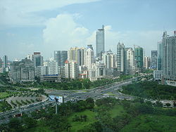
City Name:Nanning (Chinese: 南宁, Pinyin: Nánníng)
-
Population :Municipality 22,293 square kilometers
-
Location :Situated at 22°12′23″N 107°45′108″E
-
Overview:Nanning is located in the southern part of Guangxi Zhuang Autonomous Region, 160 km from the border with Vietnam.
Nanning climate
Located to the south of the tropic of cancer, Nanning has a monsoon climate characteristic of the subtropical zone and is influenced by the regulation of a maritime climate. The city is full of sunshine with abundant rainfall, but with little frost and no snowfall.
The frost-free period is between 345 and 360 days. There is an old saying that "grass never withers, even in winter; flowers always bloom, even not in spring."
Nanning weather
Summers are hot and humid with 33°C average highs in July and August. Winters are humid and chilly with 10°C average lows in January. The annual average temperature is 21.7 degrees centigrade, with the annual average precipitation of 1300 mm.
| Month | Jan | Feb | Mar | Apr | May | Jun | Jul | Aug | Sep | Oct | Nov | Dec | |
|---|---|---|---|---|---|---|---|---|---|---|---|---|---|
| Avg high °C | 17 | 18 | 21 | 26 | 30 | 32 | 33 | 32 | 31 | 28 | 24 | 20 | |
| Avg low temperature °C | 10 | 11 | 15 | 19 | 23 | 25 | 25 | 25 | 24 | 20 | 15 | 11 | |
Nanning weather forecast

The Detian Waterfall in the Guangxi Zhuang Autonomous Region, it lies in a subtropical area along the Sino-Vietnamese border, and is the second largest transnational waterfall in the world.

Tianci Lake is the central scenic area on Qingxiu Hill. On its southern bank is a long corridor leading to Longxiang Pagoda on the top of the hill.